From object From object |
| Shelfmark: |
 QE381.F8 G93 ++ QE381.F8 G93 ++ |
| Type: |
map |
| Dimension: |
|
| |
 Component's data Component's data |
| Type: |
map |
| Text: |
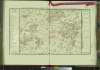
Carte min�ralogique de la partie occidentale du Valois et de l'Isle de France adjacente. |
| Comment: |
With handwritten numeration (26) on the upper right part of the map. The map was probably in state of proof.
Monnet claims (on p. xii on the 1780 edition of the Atlas) that the author of this map was Guettard alone. However, given the presence of the geological cross section (explicitly attributed by Guettard to Lavoisier), Lavoisier certainly contributed to the production of at least this part of the map. |
|
|
| From object |
| Shelfmark: |
Atlas et description BD |
| Type: |
book |
| Dimension: |
|
|
|
| Component's data |
| Type: |
atlas |
| Text: |
Atlas et description min�ralogiques de la France, Entrepris par ordre du Roi, par MM. Guettard et Monnet. Publi�e par M. Monnet, d'apr�s ses nouveaux voyages. Premier partie, comprenant le Beauvoisis, la Picardie, le Boulonnais, la Flandre Fran�aise, le Soissonnais, la Lorraine Allemande, une partie de la Lorraine Fran�aise, le pays Messin, et une partie de la Champagne |
|